- Introduction
- Data Summary
- Exploratory Data Analysis
- Data Cleaning
- Data Visualisation
- Conclusions
- References
Introduction
The Geocomputation with R book has a great example of transport analysis in Bristol.
I decided this is a chance to get to know Open Street Map (OSM) and its data better given the flurry of bike route construction.
This is a bicycle network analysis of Auckland using open source spatial and bike counter data for 2018. It is a data cleaning intensive analysis, so if you would just like to see the results, skip to the Data Visualisation section.
# Load packages
library(tidyverse)
library(sf)
library(osmdata) # Open street map (OSM) data retrieval package
library(stringi) # for name reprex
library(stplanr) # Geographic transport data package
library(tmap) # Interactive leaflet maps
#library(kable)
library(kableExtra) # table output formatting
Data
We will source data from OSM, Auckland Transport(AT) and data.govt.nz.
For consistency and ease of use, we will also transform data into sf objects for analysis and plotting.
OSM Data
Use the osmdata R package to get Auckland OSM data. We will also reference the OSM wiki for bicyles which indicates the relevant data to source :
- key = ‘highway’,value= ‘cycleway’
- key = ‘bicycle’
# Get Auckland region polygon
auckland_region <- getbb(place_name ="auckland city", format_out = "sf_polygon")
# Get the OSM auckland data and highways features, use the Overpass query  specifying the bounding box with function bbox, and return as sf using osmdata_sf
highways <- getbb(place_name='auckland,new zealand') %>%
      # The opq function obtains data from the overpass API
      opq() %>%
      # Specify the features to add using add_osm_feature. Each feature successively added will be logically AND as per vignette
      add_osm_feature(key = 'highway',value= 'cycleway') %>%
      osmdata_sf () %>%
      # Remove redundant items from the different components of an osmdata object to save memory
      unique_osmdata()
# Get the OSM auckland data and bike lanes features, we can simplify the opq function to include the bbox call in the getbb function
bikes <- opq(bbox='auckland') %>%
      # Specify the features to add using add_osm_feature. Each feature successively added will be logically with 'AND'
      add_osm_feature(key = 'bicycle') %>%
      osmdata_sf () %>%
      # Remove redundant items from the different components of an osmdata object to save memory
      unique_osmdata()
AT Dike Counter Data
Get the AT bike counter data using the readxl R package. Note there may be some potential limitations with counter data.
url <- "https://at.govt.nz/media/1979441/monthlyakldcyclecountdatanov2010-dec2018.csv"
bikes_monthly <-read_csv(url)
## Parsed with column specification:
## cols(
## .default = col_number(),
## Month = col_character(),
## `Archibald Park` = col_character(),
## `Beach Rd` = col_character(),
## `Canada St` = col_character(),
## `Carlton Gore Rd` = col_character(),
## `Curran St` = col_character(),
## `Dominion Rd (near Balmoral Rd)` = col_character(),
## `Dominion Rd (near View Rd)` = col_character(),
## `East Coast Rd` = col_character(),
## `Glen Innes (Te Ara ki Uta ki Tai)` = col_character(),
## `Grafton Bridge` = col_character(),
## `Grafton Gully` = col_character(),
## `Grafton Rd` = col_character(),
## `Gt Nth Rd (citybound only until May 2017)` = col_character(),
## `G Sth Road` = col_character(),
## Highbrook = col_character(),
## `Hopetoun St` = col_character(),
## `K Rd` = col_character(),
## `Lagoon Dr` = col_character(),
## `Lake Road` = col_character()
## # ... with 1 more columns
## )## See spec(...) for full column specifications.Auckland Cycle Network Data
Load the Auckland Cycle Network (ACN) data from data.govt.nz using rgdal R package.
url2 <- "http://data-atgis.opendata.arcgis.com/datasets/75bbb3afce054ee9a2826fd89c18e4bf_0.geojson"
acn_lines <- rgdal::readOGR(url2,stringsAsFactors = FALSE)
## OGR data source with driver: GeoJSON
## Source: "http://data-atgis.opendata.arcgis.com/datasets/75bbb3afce054ee9a2826fd89c18e4bf_0.geojson", layer: "75bbb3afce054ee9a2826fd89c18e4bf_0"
## with 1312 features
## It has 12 fieldsData Summary
Let’s take a look at summaries of the datasets.
OSM Data
# Check the class and summary of the auckland polygon
auckland_region
## Simple feature collection with 1 feature and 0 fields
## geometry type: POLYGON
## dimension: XY
## bbox: xmin: 173.8963 ymin: -37.36447 xmax: 175.9032 ymax: -35.69839
## epsg (SRID): 4326
## proj4string: +proj=longlat +datum=WGS84 +no_defs
## geometry
## 1 POLYGON ((173.8963 -36.5586...# Check the class of the bikes data, this will be similar class to highways data
class(bikes)## [1] "list" "osmdata" "osmdata_sf"# Take a look at the bikes dataset summary
bikes## Object of class 'osmdata' with:
## $bbox : -37.0134665,174.6055514,-36.6934665,174.9255514
## $overpass_call : The call submitted to the overpass API
## $timestamp : [ Mon 2 Apr 2019 17:49:23 ]
## $osm_points : 'sf' Simple Features Collection with 165 points
## $osm_lines : 'sf' Simple Features Collection with 1356 linestrings
## $osm_polygons : 'sf' Simple Features Collection with 9 polygons
## $osm_multilines : 'sf' Simple Features Collection with 7 multilinestrings
## $osm_multipolygons : 'sf' Simple Features Collection with 0 multipolygonsThe bikes OSM data has been retrieved as an list, osmdata, osmdata_sf object. However within the list there are osm_* objects that have been retrieved as sf, data.frame objects.
# Take a look at the polygons and lines data for each of bikes removing the columns with all NAs and names with NAs
bikes$osm_polygons %>%
      filter(!is.na(name)) %>%
      select_if(~!all(is.na(.))) %>%
      glimpse()
## Observations: 2
## Variables: 13
## $ osm_id <fct> 8096920, 306899273
## $ name <fct> Aotea Square, Fernglen Garden Bush Walk
## $ access <fct> NA, yes
## $ area <fct> yes, NA
## $ bicycle <fct> yes, no
## $ foot <fct> NA, yes
## $ highway <fct> pedestrian, track
## $ horse <fct> no, NA
## $ lit <fct> yes, NA
## $ motor_vehicle <fct> NA, no
## $ name.ja <fct> アオテア・スクエア, NA
## $ surface <fct> paved, NA
## $ geometry <POLYGON [°]> POLYGON ((174.7631 -36.8517..., POLYGON...bikes_lines <- bikes$osm_lines %>%
filter(!is.na(name)) %>%
select_if(~!all(is.na(.)))
bikes_lines %>%
glimpse()## Observations: 447
## Variables: 85
## $ osm_id <fct> 4279735, 4279736, 4282804, 4290919,...
## $ name <fct> Darby Street, Elliott Street, Alfre...
## $ FIXME <fct> NA, NA, NA, NA, NA, NA, NA, NA, NA,...
## $ LINZ.layer <fct> NA, NA, NA, NA, NA, NA, NA, NA, NA,...
## $ LINZ.source_version <fct> NA, NA, NA, NA, NA, NA, NA, NA, NA,...
## $ access <fct> NA, NA, NA, yes, no, NA, NA, NA, NA...
## $ alt_name <fct> NA, NA, NA, NA, NA, NA, NA, NA, NA,...
## $ attribution <fct> NA, NA, NA, NA, NA, NA, NA, NA, NA,...
## $ bicycle <fct> yes, yes, yes, yes, yes, yes, yes, ...
## $ bridge <fct> NA, NA, NA, NA, NA, NA, NA, NA, via...
## $ bridge.movable <fct> NA, NA, NA, NA, NA, NA, NA, NA, NA,...
## $ bus <fct> NA, NA, yes, NA, NA, NA, NA, NA, NA...
## $ bus.lanes <fct> NA, NA, NA, NA, NA, NA, NA, NA, NA,...
## $ bus.lanes.backward <fct> NA, NA, NA, NA, NA, NA, NA, NA, NA,...
## $ bus.lanes.forward <fct> NA, NA, NA, NA, NA, NA, NA, NA, NA,...
## $ construction <fct> NA, NA, NA, NA, NA, NA, NA, NA, NA,...
## $ contact.website <fct> NA, NA, NA, NA, NA, NA, NA, NA, NA,...
## $ covered <fct> NA, NA, NA, NA, NA, NA, NA, NA, NA,...
## $ cycleway <fct> NA, NA, NA, NA, NA, NA, NA, NA, NA,...
## $ cycleway.both <fct> NA, NA, NA, no, NA, NA, NA, NA, NA,...
## $ cycleway.left <fct> NA, NA, NA, NA, NA, NA, NA, NA, NA,...
## $ description <fct> NA, NA, NA, NA, NA, NA, NA, NA, NA,...
## $ designation <fct> NA, NA, NA, NA, NA, NA, NA, NA, NA,...
## $ destination <fct> NA, NA, NA, NA, NA, NA, NA, NA, NA,...
## $ destination.lanes <fct> NA, NA, NA, NA, NA, NA, NA, NA, NA,...
## $ destination.ref <fct> NA, NA, NA, NA, NA, NA, NA, NA, NA,...
## $ destination.ref.lanes <fct> NA, NA, NA, NA, NA, NA, NA, NA, NA,...
## $ destination.ref.to <fct> NA, NA, NA, NA, NA, NA, NA, NA, NA,...
## $ destination.ref.to.lanes <fct> NA, NA, NA, NA, NA, NA, NA, NA, NA,...
## $ destination.street <fct> NA, NA, NA, NA, NA, NA, NA, NA, NA,...
## $ duration <fct> NA, NA, NA, NA, NA, NA, NA, NA, NA,...
## $ ele <fct> NA, NA, NA, NA, NA, NA, NA, NA, NA,...
## $ emergency_response_section <fct> NA, NA, NA, NA, NA, NA, NA, NA, NA,...
## $ foot <fct> yes, yes, yes, yes, yes, yes, NA, N...
## $ goods.conditional <fct> NA, NA, NA, NA, NA, NA, NA, NA, NA,...
## $ hgv.conditional <fct> NA, NA, NA, NA, NA, NA, NA, NA, NA,...
## $ highway <fct> living_street, living_street, uncla...
## $ horse <fct> NA, NA, NA, NA, NA, NA, NA, NA, NA,...
## $ junction.ref <fct> NA, NA, NA, NA, NA, NA, NA, NA, NA,...
## $ lanes <fct> NA, NA, 1, NA, 1, NA, NA, 1, 2, 1, ...
## $ lanes.backward <fct> NA, NA, NA, NA, NA, NA, NA, NA, NA,...
## $ lanes.forward <fct> NA, NA, NA, NA, NA, NA, NA, NA, NA,...
## $ layer <fct> NA, NA, NA, NA, NA, NA, NA, NA, 1, ...
## $ lit <fct> NA, NA, NA, yes, NA, NA, NA, NA, NA...
## $ man_made <fct> NA, NA, NA, NA, NA, NA, NA, NA, NA,...
## $ maxspeed <fct> 10, 10, 10, 50, NA, NA, 50, 50, 80,...
## $ maxspeed.type <fct> NA, NA, NA, NA, NA, NA, NA, NA, NA,...
## $ maxspeed.variable <fct> NA, NA, NA, NA, NA, NA, NA, NA, NA,...
## $ mooring <fct> NA, NA, NA, NA, NA, NA, NA, NA, NA,...
## $ motor_vehicle <fct> NA, NA, no, yes, NA, yes, NA, NA, N...
## $ motorcar <fct> NA, NA, NA, NA, NA, NA, NA, NA, NA,...
## $ motorcar.conditional <fct> NA, NA, NA, NA, NA, NA, NA, NA, NA,...
## $ motorcycle <fct> NA, NA, NA, NA, NA, NA, NA, NA, NA,...
## $ name.ja <fct> NA, NA, NA, NA, NA, NA, NA, NA, NA,...
## $ note <fct> NA, NA, NA, NA, NA, NA, NA, NA, NA,...
## $ oneway <fct> yes, yes, yes, NA, yes, NA, no, yes...
## $ proposed <fct> NA, NA, NA, NA, NA, NA, NA, NA, NA,...
## $ psv <fct> NA, NA, yes, NA, yes, NA, NA, NA, N...
## $ railway <fct> NA, NA, NA, NA, NA, NA, NA, NA, NA,...
## $ ref <fct> NA, NA, NA, NA, NA, NA, NA, NA, 10,...
## $ route <fct> NA, NA, NA, NA, NA, NA, NA, NA, NA,...
## $ sac_scale <fct> NA, NA, NA, NA, NA, NA, NA, NA, NA,...
## $ segregated <fct> NA, NA, NA, NA, NA, NA, NA, NA, NA,...
## $ service <fct> NA, NA, NA, NA, NA, NA, NA, NA, NA,...
## $ sidewalk <fct> NA, NA, NA, NA, NA, NA, NA, NA, NA,...
## $ source <fct> NA, NA, NA, NA, NA, NA, NA, NA, NA,...
## $ source.geometry <fct> NA, NA, NA, NA, NA, NA, NA, NA, NA,...
## $ source.maxspeed <fct> NA, NA, NA, NA, NA, NA, NA, NA, NA,...
## $ source.oneway <fct> NA, NA, NA, NA, NA, NA, NA, NA, NA,...
## $ source_ref <fct> NA, NA, NA, NA, NA, NA, NA, NA, NA,...
## $ start_date <fct> NA, NA, NA, NA, NA, NA, NA, NA, NA,...
## $ surface <fct> asphalt, asphalt, NA, paved, NA, NA...
## $ tracktype <fct> NA, NA, NA, NA, NA, NA, NA, NA, NA,...
## $ trail_visibility <fct> NA, NA, NA, NA, NA, NA, NA, NA, NA,...
## $ tunnel <fct> NA, NA, NA, NA, NA, NA, NA, NA, NA,...
## $ turn.lanes <fct> NA, NA, NA, NA, NA, NA, NA, NA, NA,...
## $ turn.lanes.backward <fct> NA, NA, NA, NA, NA, NA, NA, NA, NA,...
## $ turn.lanes.forward <fct> NA, NA, NA, NA, NA, NA, NA, NA, NA,...
## $ type <fct> NA, NA, NA, NA, NA, NA, NA, NA, NA,...
## $ vehicle <fct> NA, NA, no, NA, NA, NA, NA, NA, NA,...
## $ visibility <fct> NA, NA, NA, NA, NA, NA, NA, NA, NA,...
## $ width <fct> NA, NA, NA, NA, NA, NA, NA, NA, NA,...
## $ wikidata <fct> NA, NA, NA, NA, NA, NA, NA, NA, NA,...
## $ wikipedia <fct> NA, NA, NA, NA, NA, NA, NA, NA, NA,...
## $ geometry <LINESTRING [°]> LINESTRING (174.765 -36...# Tabulate the highway variable for more information on the categories
table(bikes_lines$highway)##
## bridleway construction cycleway footway living_street
## 0 1 5 40 10
## motorway motorway_link path pedestrian primary
## 32 1 60 3 110
## proposed residential secondary service steps
## 1 13 88 2 0
## tertiary track trunk trunk_link unclassified
## 6 22 36 0 14It looks like the bikes$osm_polygons data relate to pedestrian and track data, and the rest of the polygons are not named. We will ignore the bikes$osm_polygons data and use the bikes$osm_lines data.
# Take a look at the highways dataset summary
highways
## Object of class 'osmdata' with:
## $bbox : -37.0134665,174.6055514,-36.6934665,174.9255514
## $overpass_call : The call submitted to the overpass API
## $timestamp : [ Mon 2 Apr 2019 17:49:16 ]
## $osm_points : 'sf' Simple Features Collection with 0 points
## $osm_lines : 'sf' Simple Features Collection with 651 linestrings
## $osm_polygons : 'sf' Simple Features Collection with 12 polygons
## $osm_multilines : 'sf' Simple Features Collection with 0 multilinestrings
## $osm_multipolygons : 'sf' Simple Features Collection with 0 multipolygonsThe OSM highways data has been retrieved as an list, osmdata, osmdata_sf object. However within the list there are osm_* objects that have been retrieved as sf, data.frame objects.
highways_lines <- highways$osm_lines %>%
      filter(!is.na(name)) %>%
      select_if(~!all(is.na(.)))
highways_lines %>%
      glimpse()
## Observations: 183
## Variables: 35
## $ osm_id <fct> 12249855, 12250191, 23215852, 23215865, 2...
## $ name <fct> Waikaraka Cycleway, Waikaraka Cycleway, N...
## $ LINZ.source_version <fct> NA, NA, NA, NA, NA, NA, NA, NA, NA, NA, N...
## $ access <fct> NA, NA, NA, NA, NA, NA, NA, NA, NA, NA, N...
## $ attribution <fct> NA, NA, NA, NA, NA, NA, NA, NA, NA, NA, N...
## $ bicycle <fct> NA, NA, NA, NA, NA, NA, NA, NA, NA, NA, N...
## $ bridge <fct> NA, NA, NA, NA, NA, NA, NA, NA, NA, NA, N...
## $ colour <fct> NA, NA, NA, NA, NA, NA, NA, NA, NA, NA, N...
## $ construction <fct> NA, NA, NA, NA, NA, NA, NA, NA, NA, NA, N...
## $ construction.highway <fct> NA, NA, NA, NA, NA, NA, NA, NA, NA, NA, N...
## $ created_by <fct> NA, NA, NA, NA, Tways 0.2, NA, NA, NA, NA...
## $ cycleway <fct> NA, NA, NA, NA, NA, NA, NA, NA, NA, NA, N...
## $ foot <fct> yes, yes, yes, yes, NA, NA, yes, yes, yes...
## $ highway <fct> cycleway, cycleway, cycleway, cycleway, c...
## $ horse <fct> NA, NA, NA, NA, NA, NA, NA, NA, NA, NA, N...
## $ layer <fct> 1, NA, NA, NA, NA, NA, NA, NA, NA, NA, NA...
## $ lit <fct> NA, NA, NA, NA, NA, NA, NA, NA, NA, NA, N...
## $ man_made <fct> NA, NA, NA, NA, NA, NA, NA, NA, NA, NA, N...
## $ motor_vehicle <fct> NA, NA, NA, NA, NA, NA, NA, NA, NA, NA, N...
## $ name.en <fct> NA, NA, NA, NA, NA, NA, NA, NA, NA, NA, N...
## $ name.mi <fct> NA, NA, NA, NA, NA, NA, NA, NA, NA, NA, N...
## $ note <fct> NA, NA, NA, NA, NA, NA, NA, NA, NA, NA, N...
## $ oneway <fct> NA, NA, NA, NA, NA, NA, NA, NA, NA, NA, N...
## $ oneway.bicycle <fct> NA, NA, NA, NA, NA, NA, NA, NA, NA, NA, N...
## $ proposed <fct> NA, NA, NA, NA, NA, NA, NA, NA, NA, NA, N...
## $ smoothness <fct> NA, NA, NA, NA, NA, NA, NA, NA, NA, NA, N...
## $ source <fct> NA, NA, NA, NA, NA, NA, NA, NA, NA, NA, N...
## $ source_2 <fct> NA, NA, NA, NA, NA, NA, NA, NA, NA, NA, N...
## $ source_ref <fct> NA, NA, NA, NA, NA, NA, NA, NA, NA, NA, N...
## $ surface <fct> NA, NA, concrete, concrete, NA, NA, NA, N...
## $ tunnel <fct> NA, NA, NA, NA, NA, NA, NA, NA, NA, NA, N...
## $ website <fct> NA, NA, NA, NA, NA, NA, NA, NA, NA, NA, N...
## $ wikidata <fct> NA, NA, NA, NA, NA, NA, NA, NA, NA, NA, N...
## $ wikipedia <fct> NA, NA, NA, NA, NA, NA, NA, NA, NA, NA, N...
## $ geometry <LINESTRING [°]> LINESTRING (174.8262 -36.92.....highways$osm_polygons %>%
filter(!is.na(name)) %>%
select_if(~!all(is.na(.))) %>%
glimpse()## Observations: 2
## Variables: 7
## $ osm_id <fct> 304326461, 304337319
## $ name <fct> Sanders reserve Kids loop, Sanders Reserve recreation...
## $ foot <fct> no, no
## $ highway <fct> cycleway, cycleway
## $ horse <fct> no, no
## $ oneway <fct> yes, yes
## $ geometry <POLYGON [°]> POLYGON ((174.6375 -36.7671..., POLYGON ((17...It looks like the highways$osm_polygons data may relate to MTB loops such as Sander’s Reserve, and the rest of the polygons are not named. We will ignore the highways$osm_polygons data and use the highways$osm_lines data.
AT Bike Counter Data
Let’s take a look at a summary of the bikes counter data.
# Take a look at the monthly bikes counter data
glimpse(bikes_monthly)
## Observations: 99
## Variables: 46
## $ Month <chr> "(Te Atatu)\"", "N...
## $ `Archibald Park` <chr> "Oceanview Rd, Wai...
## $ `Beach Rd` <chr> "Orewa", NA, NA, N...
## $ `Canada St` <chr> "Ormiston Rd Flat ...
## $ `Carlton Gore Rd` <chr> "Pukekohe Queen St...
## $ `Curran St` <chr> "Quay St Spark Are...
## $ `Dominion Rd (near Balmoral Rd)` <chr> "Quay St totem", N...
## $ `Dominion Rd (near View Rd)` <chr> "Rankin Ave, New L...
## $ `East Coast Rd` <chr> "St Luke's Rd", NA...
## $ `Glen Innes (Te Ara ki Uta ki Tai)` <chr> "SH20A (sth of Kir...
## $ `Grafton Bridge` <chr> "SW shared path", ...
## $ `Grafton Gully` <chr> "Symonds St", NA, ...
## $ `Grafton Rd` <chr> "Tamaki Dr (EB + W...
## $ `Gt Nth Rd (citybound only until May 2017)` <chr> "Te Atatu Peninsul...
## $ `G Sth Road` <chr> "Te Wero Bridge", ...
## $ Highbrook <chr> "Twin Streams", "1...
## $ `Hopetoun St` <chr> "Upper Harbour", N...
## $ `K Rd` <chr> "Upper Queen St", ...
## $ `Lagoon Dr` <chr> "Victoria St West"...
## $ `Lake Road` <chr> "Waterview SP (Uni...
## $ `Mangere Bridge` <dbl> NA, NA, NA, NA, NA...
## $ `Mangere Safe Routes` <dbl> NA, NA, NA, NA, NA...
## $ `Matakana Bridge` <dbl> NA, NA, NA, NA, NA...
## $ `Nelson St cycleway` <dbl> NA, NA, NA, NA, NA...
## $ `Nelson St Lightpath` <dbl> NA, NA, NA, NA, NA...
## $ `NW Cycleway (Kingsland)` <dbl> NA, 8894, 6575, 78...
## $ `NW Cycleway \n(Te Atatu)` <dbl> NA, 12760, 9964, 1...
## $ `Oceanview Rd, Waiheke` <dbl> NA, NA, NA, NA, NA...
## $ Orewa <dbl> NA, 3305, 2564, 45...
## $ `Ormiston Rd Flat Bush` <dbl> NA, NA, NA, NA, NA...
## $ `Pukekohe Queen St` <int> NA, NA, NA, NA, NA...
## $ `Quay St Spark Arena` <dbl> NA, NA, NA, NA, NA...
## $ `Quay St totem` <dbl> NA, NA, NA, NA, NA...
## $ `Rankin Ave, New Lynn` <dbl> NA, NA, NA, NA, NA...
## $ `St Luke's Rd` <dbl> NA, NA, NA, NA, NA...
## $ `SH20A (sth of Kirkbride)` <dbl> NA, NA, NA, NA, NA...
## $ `SW shared path` <dbl> NA, NA, NA, NA, NA...
## $ `Symonds St` <dbl> NA, NA, NA, NA, NA...
## $ `Tamaki Dr (EB + WB)` <dbl> NA, NA, NA, NA, NA...
## $ `Te Atatu Peninsula` <dbl> NA, NA, NA, NA, NA...
## $ `Te Wero Bridge` <dbl> NA, NA, NA, NA, NA...
## $ `Twin Streams` <dbl> NA, 3025, 2796, 45...
## $ `Upper Harbour` <dbl> NA, 3648, 2487, 40...
## $ `Upper Queen St` <dbl> NA, NA, NA, NA, NA...
## $ `Victoria St West` <dbl> NA, NA, NA, NA, NA...
## $ `Waterview SP (Unitec)` <dbl> NA, NA, NA, NA, NA...Auckland Cycle Network Data
Finally take a look at the acn_lines bikes network.
acn_lines[1,1]## class : SpatialLinesDataFrame
## features : 1
## extent : 174.6714, 174.677, -36.59282, -36.59208 (xmin, xmax, ymin, ymax)
## coord. ref. : +proj=longlat +datum=WGS84 +no_defs +ellps=WGS84 +towgs84=0,0,0
## variables : 1
## names : OBJECTID
## value : 1001Exploratory Data Analysis
Since the data are sf objects, we can use ggplot2 to create quick initial EDA plots.
OSM data
Let’s first take a look at the OSM data using ggplot2, plotting the bike_lines and highways_lines in darkorange.
# Creat a ggplot map of the bike_lines dataset
ggplot()+
      geom_sf(data=bikes_lines,colour="darkorange")+
      geom_sf(data=auckland_region,fill=NA)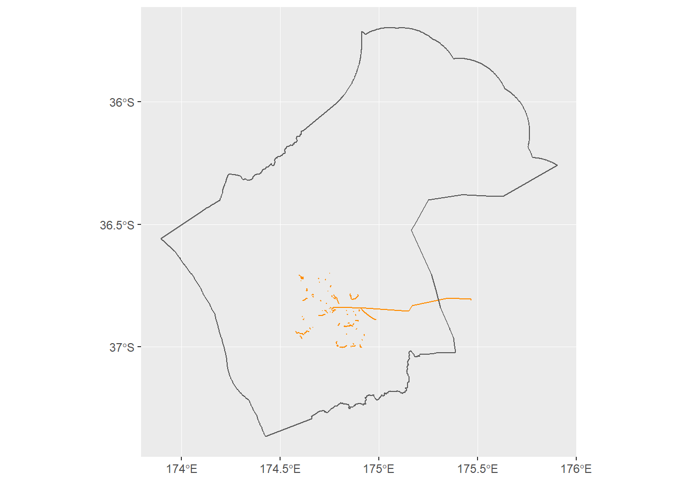
It appears that there may be ferry routes included in the data. We will remove these in the cleaning steps.
# Creat a ggplot map of the highways_lines dataset
ggplot()+
      geom_sf(data=highways_lines,colour="darkorange")+
      geom_sf(data=auckland_region,fill=NA)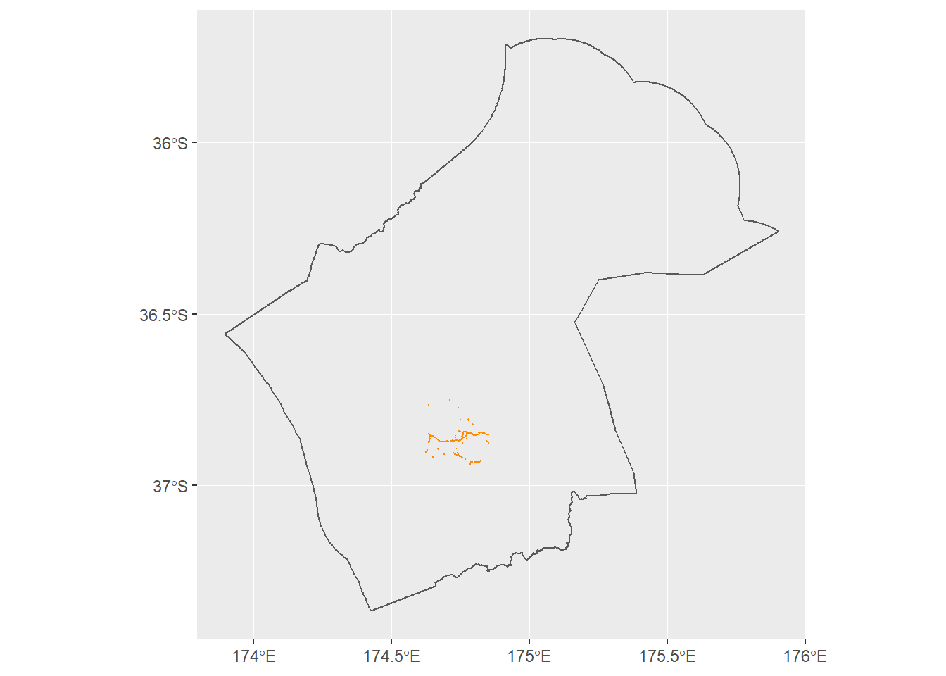
Auckland Cycle Network Data
Now plot the acn_lines in purple.
# Creat a ggplot map of the acn_lines dataset, converting the SpatialDataFrame to an sf object
acn_lines_sf<- acn_lines  %>%
      st_as_sf()
ggplot()+
      geom_sf(data=acn_lines_sf,colour="purple")+
      geom_sf(data=auckland_region,fill=NA)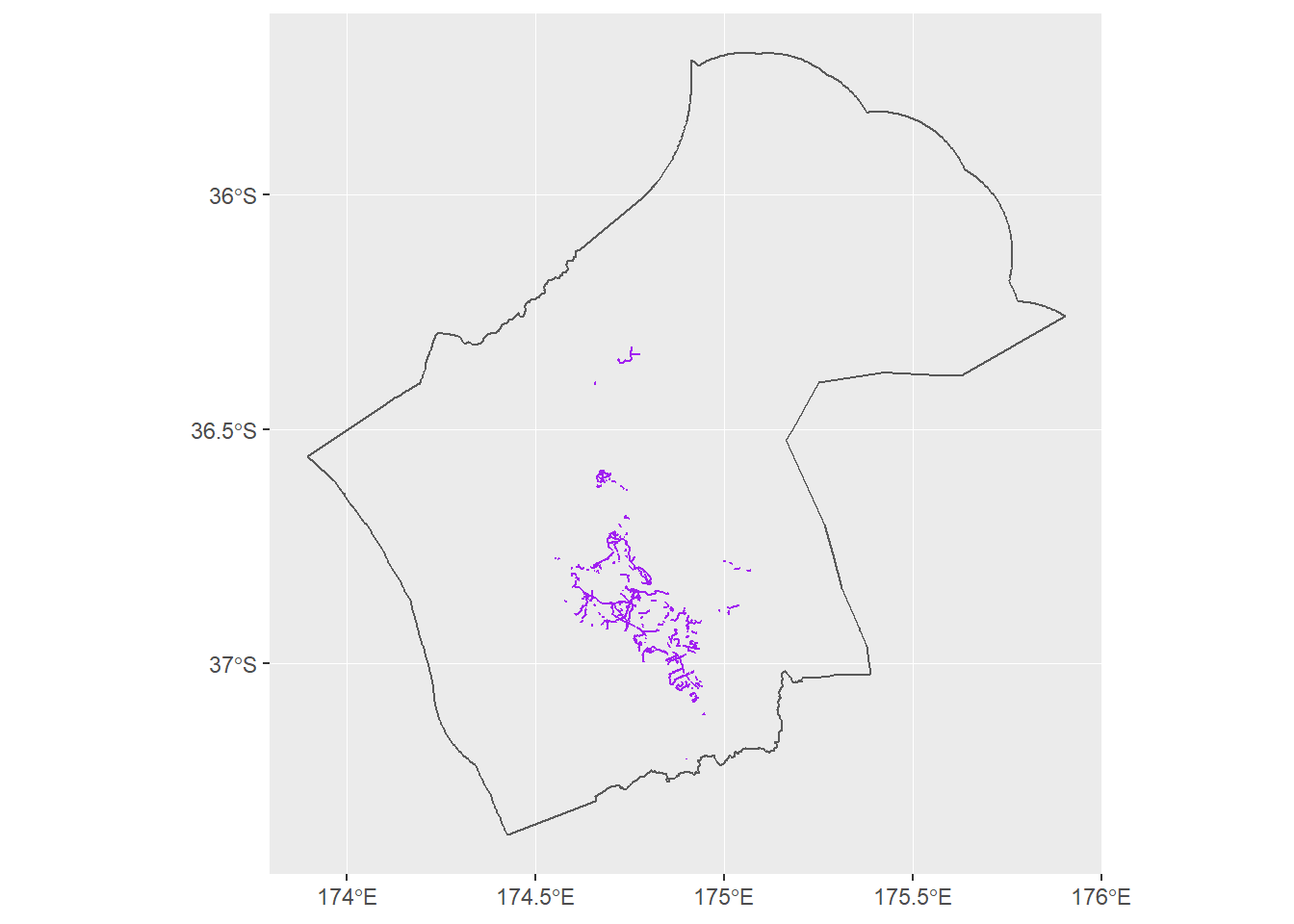
The acn_lines data looks to cover the broader Auckland region, we may need to filter to get the routes close to the city.
Now use the stplanr R package to create spatial networks. We will use the acn_lines object as this is imported with class SpatialLinesDataFrame. Then visualise network centrality and plot the edge betweenness.
# Creat a composite object with slots, where the s argument is a SpatialLinesDataFrame
acn_lines_sln <- SpatialLinesNetwork(acn_lines)
# Take a look at the class of the new object
class(acn_lines_sln)
## [1] "SpatialLinesNetwork"
## attr(,"package")
## [1] "stplanr"# Take a look at the slot names
slotNames(acn_lines_sln)## [1] "sl" "g" "nb" "weightfield"# Take a look at the class of the graph component, g
class(acn_lines_sln@g)## [1] "igraph"The SpatialLinesNetwork function creates a SpatialLinesNetwork object creates sl, g, nb, weightfield components. We can plot the g (graph) and sl (spatial) components.
e <- igraph::edge_betweenness(acn_lines_sln@g)
# Plot the igraph  from the sl component and the edge from the g component
plot(acn_lines_sln@sl,
     lwd = e / 10,
     col = "purple")
This is a very brief look at potential nodes in the network.
Data Cleaning
OSM Data
First we will transform the CRS of the datasets for spatial mapping.
# Get nz data set with CRS set
nz <- spData::nz
# Transform the osm data to the nz CRS for plotting
bikes_wgs84 <- st_transform(bikes_lines, st_crs(nz))
# Transform the osm line data to the nz CRS for plotting
highways_lines_wgs84 <- st_transform(highways_lines , st_crs(nz))
highways_lines_wgs84$name <- as.character(highways_lines_wgs84$name)# Correct spelling of Grafton Gully Cycleway in the OSM file. This change has also been proposed in OSM - changeset #: 68819107
highways_lines_wgs84$name <- highways_lines_wgs84$name %>%
str_replace_all( pattern = "Grafton Gully cycleway", replacement = "Grafton Gully Cycleway")Now we will get the bbox of the highways_lines_wgs84 data and use this bbox for the maps.
# Use st_bbox to get bbox coordinates
bbox_plots <- st_bbox(highways_lines_wgs84)
Next remove the ferry routes.
bikes_wgs84 <- bikes_wgs84 %>%
      filter(route!="ferry")
AT Bike Counter Data
We will tidy the bike counter data with the tidyr R package so that we can join it to the OSM and acn_lines_sf data. We will use the stringr and stringi R packages for regex.
# Remove the first row of the dataset
bikes_monthly <- bikes_monthly %>%
      slice(-1)
# Convert the character date variable to a date variable using lubridate
bikes_monthly$Month <- lubridate::dmy(paste0("01-",bikes_monthly$Month))
# Add a year variable
bikes_monthly <- bikes_monthly %>%
      mutate(Year=lubridate::year(Month))
# Create a tidy dataframe filtered for complete 2018 data
bikes_2018 <- bikes_monthly %>%
      filter(Year==2018) %>%
      select_if(~!any(is.na(.))) %>%
      gather(key = "Street",value="counts",2:41) %>%
      # Add Cycleway to the name which will be used to join with the osm data
      mutate(name=paste0(Street," Cycleway"))
# Update the names in the counter sum file to match with some names in the osm data
bikes_2018$name <- bikes_2018$name %>%
      str_replace_all( c( "Rd "= "Road ",
                          "Nelson St Lightpath Cycleway" = "Te Ara I Whiti (The Lightpath)",
                          "Quay St Spark Arena Cycleway" = "Quay Street Cycleway",
                          "Quay St totem Cycleway"= "Quay Street Cycleway",
                          "Grafton Bridge Cycleway" = "Grafton Bridge",
                          "Nelson St cycleway Cycleway" = "Nelson Street Cycleway",
                          "Te Wero Bridge Cycleway" = "Te Wero Bridge",
                          "Lake Road Cycleway" = "Lake Road"))   %>%
      # For replacements with brackets we need to use stringi
      stringi::stri_replace_all_fixed( pattern = "Tamaki Dr (EB + WB) Cycleway", replacement = "Tamaki Drive Cycleway") %>%
      stringi::stri_replace_all_fixed( pattern = "Dominion Road (near View Road) Cycleway", replacement =  "Dominion Road West Safe Cycle Route")%>%
      stringi::stri_replace_all_fixed( pattern = "NW Cycleway (Kingsland) Cycleway", replacement = "Northwestern Cycleway") %>%
      stringi::stri_replace_all_fixed( pattern = "NW Cycleway \n(Te Atatu) Cycleway", replacement = "Northwestern Cycleway")

# Convert the remove the comma from the character and counts to numeric using stringr str_replace
bikes_2018$counts <- as.numeric(stringr::str_replace_all(bikes_2018$counts, pattern= ",", replacement = ""))
Now let’s view the 2018 bike counter monthly data as a facet plot by street name to visualise trends and which routes may be the busier routes.
# Take a look at the monthly bike counter line plots
# bikes_2018$Month <- stri_wrap(bikes_2018$Month,n=13) # tried to wrap titles but it doesn't currently work
ggplot(bikes_2018,aes(Month,counts)) +
      geom_line()+
      facet_wrap(~Street)+
      theme(axis.title.x=element_blank(),
        axis.text.x=element_blank(),
        axis.ticks.x=element_blank())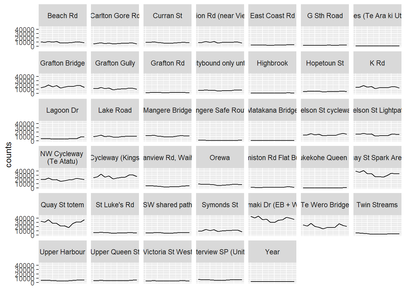
The popular routes have seasonality with numbers dipping in the winter months. The less popular routes have flat, low numbers.
# Total the counts by street for 2018
bikes_2018_sum <- bikes_2018 %>%
      group_by(name) %>%
      summarise(Total =sum(counts))
# View the top 20 busiest routes in 2018 according to the bike counter data
bikes_2018_sum %>%
      arrange(desc(Total)) %>%
      head(20) %>%
knitr::kable(format = "markdown")| name | Total |
|---|---|
| Quay Street Cycleway | 738166 |
| Northwestern Cycleway | 558061 |
| Tamaki Drive Cycleway | 454885 |
| Te Wero Bridge | 254055 |
| Grafton Bridge | 198657 |
| K Road Cycleway | 177635 |
| Te Ara I Whiti (The Lightpath) | 172441 |
| Nelson Street Cycleway | 171848 |
| Grafton Gully Cycleway | 137844 |
| Mangere Bridge Cycleway | 134360 |
| Symonds St Cycleway | 132282 |
| Lake Road | 125154 |
| Beach Road Cycleway | 115011 |
| Dominion Road (near View Rd) Cycleway | 112206 |
| Curran St Cycleway | 105325 |
| Orewa Cycleway | 96110 |
| Gt Nth Road (citybound only until May 2017) Cycleway | 89095 |
| Carlton Gore Road Cycleway | 82532 |
| Waterview SP (Unitec) Cycleway | 73606 |
| St Luke’s Road Cycleway | 68954 |
Auckland Cycle Network Data
# Transform the osm line data to the nz CRS for plotting
acn_lines_wgs84 <- st_transform(acn_lines_sf %>%
      filter(!is.na(ROADNAME)) , st_crs(nz))
# Update the names in the acn data file to match with some names in the osm data https://stringr.tidyverse.org/articles/regular-expressions.html
acn_lines_wgs84$ROADNAME <- acn_lines_wgs84$ROADNAME %>%
str_replace_all(c("St$" = "Street",
"Street$" = "Street Cycleway",
"Dr$" = "Drive",
"dr$" = "Drive",
"Drive$" = "Drive Cycleway",
"Rd$" = "Road",
"Road$" = "Road Cycleway",
"Grafton Bridge Cycleway" = "Grafton Bridge",
"Jellico St-Bauemont Street Cycleway"="Te Wero Bridge",
"Lake Road Cycleway"="Lake Road",
"SH20 Mangere Motorway Bridge" = "Mangere Bridge Cycleway")) %>%
stringi::stri_replace_all_fixed( pattern="Northwestern Cycleway (Great North to Lincoln)", replacement = "Northwestern Cycleway") %>%
stringi::stri_replace_all_fixed( pattern="Northwestern Cycleway (Newton Rd to Great North Road)",replacement = "Northwestern Cycleway") %>%
stringi::stri_replace_all_fixed( pattern="Dominion Road Cycleway Cycleway",replacement = "Dominion Road (near View Rd) Cycleway") %>%
stringi::stri_replace_all_fixed( pattern="The Lightpath",replacement = "Te Ara I Whiti (The Lightpath)") %>%
stringi::stri_replace_all_fixed( pattern="Harbour Edge (Quay St)",replacement = "Quay Street Cycleway") # Remove large datasets to save memory
rm(bikes)
rm(highways)
rm(acn_lines)
rm(acn_lines_sf)Combine Data
Now combine the total counts with the osm and the acn_lines datasets.
# Join the total sums to the osm highways lines data
highways_lines_wgs84_sum <- left_join(highways_lines_wgs84,bikes_2018_sum, by="name")
# Join the total sums to the osm highways lines data
bikes_wgs84_sum <- left_join(bikes_wgs84,bikes_2018_sum, by="name")
# Join the total sums to the osm acn lines data
acn_lines_wgs84_sum <- left_join(acn_lines_wgs84,bikes_2018_sum, by=c("ROADNAME"="name"))# Row bind the dataframe components
bikenet_wgs84 <- bind_rows(data.frame(highways_lines_wgs84_sum %>% select(name,osm_id,Total)),
data.frame(bikes_wgs84_sum %>% select(name,osm_id,Total)))
# Row bind the geometry components
bikenet_wgs84$geometry <- c(highways_lines_wgs84_sum$geometry,bikes_wgs84_sum$geometry)
# Convert back to sf
bikenet_wgs84 <- bikenet_wgs84 %>%
st_as_sf()# Let's check which of the top 20 we have covered in our osm network
bikes_2018_sum %>%
mutate('In counter?'="yes") %>%
arrange(desc(Total)) %>%
head(20) %>%
full_join(bikenet_wgs84 %>%
select(name) %>%
mutate('In network?'="yes") %>%
st_set_geometry(NULL)
, by = "name") %>%
unique() %>%
knitr::kable() %>%
kable_styling() %>%
scroll_box(width = "800px", height = "200px")| name | Total | In counter? | In network? |
|---|---|---|---|
| Quay Street Cycleway | 738166 | yes | yes |
| Northwestern Cycleway | 558061 | yes | yes |
| Tamaki Drive Cycleway | 454885 | yes | yes |
| Te Wero Bridge | 254055 | yes | NA |
| Grafton Bridge | 198657 | yes | NA |
| K Road Cycleway | 177635 | yes | NA |
| Te Ara I Whiti (The Lightpath) | 172441 | yes | yes |
| Nelson Street Cycleway | 171848 | yes | yes |
| Grafton Gully Cycleway | 137844 | yes | yes |
| Mangere Bridge Cycleway | 134360 | yes | NA |
| Symonds St Cycleway | 132282 | yes | NA |
| Lake Road | 125154 | yes | NA |
| Beach Road Cycleway | 115011 | yes | yes |
| Dominion Road (near View Rd) Cycleway | 112206 | yes | NA |
| Curran St Cycleway | 105325 | yes | NA |
| Orewa Cycleway | 96110 | yes | NA |
| Gt Nth Road (citybound only until May 2017) Cycleway | 89095 | yes | NA |
| Carlton Gore Road Cycleway | 82532 | yes | yes |
| Waterview SP (Unitec) Cycleway | 73606 | yes | NA |
| St Luke’s Road Cycleway | 68954 | yes | NA |
| Waikaraka Cycleway | NA | NA | yes |
| Abbotsford Way | NA | NA | yes |
| Takapuna Cycle Route | NA | NA | yes |
| Onepoto Cycleway | NA | NA | yes |
| Coronation Road | NA | NA | yes |
| Southern Isthmus Cycleway | NA | NA | yes |
| Henderson Creek shared path | NA | NA | yes |
| International Walkway of Trees | NA | NA | yes |
| North West Route | NA | NA | yes |
| Oratia Stream Shared Path | NA | NA | yes |
| Arch Hill Mountain Bike Trails | NA | NA | yes |
| Upper Waikumete Walk and Cycleway | NA | NA | yes |
| Te Whau Pathway | NA | NA | yes |
| Rosedale to Unsworth heights | NA | NA | yes |
| Rosedale to Unsworth hieghts | NA | NA | yes |
| Ian McKinnon Drive Cycleway | NA | NA | yes |
| Westhaven Promenade | NA | NA | yes |
| Sanders Reserve kowhai loop | NA | NA | yes |
| Recreational loop short cut | NA | NA | yes |
| Eric Armishaw Reserve Walkway | NA | NA | yes |
| Eric Armishaw Boardwalk | NA | NA | yes |
| Pitt Street Cycleway | NA | NA | yes |
| Britomart Place Cycleway | NA | NA | yes |
| Dominion Road East Safe Cycle Route | NA | NA | yes |
| Dominion Road West Safe Cycle Route | NA | NA | yes |
| Te Ara Ki Uta Ki Tai | NA | NA | yes |
| Grey Lynn Greenway | NA | NA | yes |
| Mt Roskill Safe Routes | NA | NA | yes |
| Avondale Kids Bike Park | NA | NA | yes |
| Mokomoko Bridge | NA | NA | yes |
| Onepoto Domain Kids Bike Park | NA | NA | yes |
| Richmond Road Cycleway | NA | NA | yes |
| Te Ara I Whiti | NA | NA | yes |
| Moire Park Pump Track | NA | NA | yes |
| Curry’s Lane Cycle Route | NA | NA | yes |
| Rainbow Path | NA | NA | yes |
| Federal Street Cycleway | NA | NA | yes |
| Tirohanga Whanui | NA | NA | yes |
If we check OpenStreetMap we can see that the Te Wero Bridge, K Road, Curran St, Mangere Bridge, Lake Road and Symonds Street Cycleways (and other less popular routes) are not currently labelled in osm data.
# Let's check which of the top 20 we have covered in our osm network
bikes_2018_sum %>%
       mutate('In counter?'="yes") %>%
       arrange(desc(Total)) %>%
       head(20) %>%
            full_join(acn_lines_wgs84_sum  %>%
                            select(ROADNAME,LOCALBOARD,STATUS) %>%
                            mutate('In acn network?'="yes") %>%
                            st_set_geometry(NULL),
                      by = c("name"="ROADNAME"))  %>%
      unique() %>%
      knitr::kable() %>%
      kable_styling() %>%
scroll_box(width = "800px", height = "200px")| name | Total | In counter? | LOCALBOARD | STATUS | In acn network? |
|---|---|---|---|---|---|
| Quay Street Cycleway | 738166 | yes | Waitemata | Existing | yes |
| Northwestern Cycleway | 558061 | yes | Albert - Eden | Existing | yes |
| Northwestern Cycleway | 558061 | yes | Whau | Existing | yes |
| Northwestern Cycleway | 558061 | yes | Henderson - Massey | Existing | yes |
| Northwestern Cycleway | 558061 | yes | Waitemata | Existing | yes |
| Tamaki Drive Cycleway | 454885 | yes | NA | Existing | yes |
| Tamaki Drive Cycleway | 454885 | yes | Orakei | Existing | yes |
| Te Wero Bridge | 254055 | yes | Waitemata | Existing | yes |
| Grafton Bridge | 198657 | yes | NA | NA | NA |
| K Road Cycleway | 177635 | yes | NA | NA | NA |
| Te Ara I Whiti (The Lightpath) | 172441 | yes | Waitemata | Existing | yes |
| Nelson Street Cycleway | 171848 | yes | Waitemata | Existing | yes |
| Grafton Gully Cycleway | 137844 | yes | Waitemata | Existing | yes |
| Mangere Bridge Cycleway | 134360 | yes | Mangere – Otahuhu | Existing | yes |
| Symonds St Cycleway | 132282 | yes | NA | NA | NA |
| Lake Road | 125154 | yes | Devonport - Takapuna | Existing | yes |
| Beach Road Cycleway | 115011 | yes | Waitemata | Existing | yes |
| Dominion Road (near View Rd) Cycleway | 112206 | yes | NA | NA | NA |
| Curran St Cycleway | 105325 | yes | NA | NA | NA |
| Orewa Cycleway | 96110 | yes | NA | NA | NA |
| Gt Nth Road (citybound only until May 2017) Cycleway | 89095 | yes | NA | NA | NA |
| Carlton Gore Road Cycleway | 82532 | yes | Waitemata | Existing | yes |
| Carlton Gore Road Cycleway | 82532 | yes | NA | Existing | yes |
| Waterview SP (Unitec) Cycleway | 73606 | yes | NA | NA | NA |
| St Luke’s Road Cycleway | 68954 | yes | NA | Existing | yes |
| St Luke’s Road Cycleway | 68954 | yes | Albert - Eden | Existing | yes |
| Buckland Road Cycleway | NA | NA | Mangere - Otahuhu | Existing | yes |
| cycleway | NA | NA | Mangere - Otahuhu | Existing | yes |
| Station Road (Papatoetoe) | NA | NA | Otara - Papatoetoe | Existing | yes |
| Salisbury Reserve | NA | NA | Waitemata | Existing | yes |
| St Georges Street Cycleway | NA | NA | Otara - Papatoetoe | Existing | yes |
| Kirkbride Road/Massey Road Cycleway | NA | NA | Mangere - Otahuhu | Existing | yes |
| Off road cycle route | NA | NA | Mangere - Otahuhu | Existing | yes |
| Puhinui Road Cycleway | NA | NA | Otara - Papatoetoe | Existing | yes |
| Lambie Drive Cycleway | NA | NA | Otara - Papatoetoe | Existing | yes |
| Puhinui Road Cycleway | NA | NA | NA | Existing | yes |
| Great South Road Cycleway | NA | NA | Otara - Papatoetoe | Existing | yes |
| Great South Road Cycleway | NA | NA | Mangere - Otahuhu | Existing | yes |
| Great South Road (East Tamaki Rd) | NA | NA | Otara - Papatoetoe | Existing | yes |
| Great South Road Cycleway | NA | NA | NA | Existing | yes |
| Great South Road Cycleway | NA | NA | Manurewa | Existing | yes |
| Sunnynook Park | NA | NA | Devonport-Takapuna | Existing | yes |
| Queen Street Cycleway | NA | NA | Franklin | Existing | yes |
| Porchester Road (Papakura end) | NA | NA | Papakura | Existing | yes |
| Kauri Heart Avenue | NA | NA | Papakura | Existing | yes |
| Hingaia Rd (Over SH1) | NA | NA | Papakura | Existing | yes |
| cycleway | NA | NA | Papakura | Existing | yes |
| Great South Road Cycleway | NA | NA | Papakura | Existing | yes |
| Off road cycle route | NA | NA | Manurewa | Existing | yes |
| Eastern Rail Cycleway (Ellerslie-Panmure Hwy to Triangle Road) | NA | NA | Maungakiekie - Tamaki | Existing | yes |
| Great South Road (Takanini) | NA | NA | Papakura | Existing | yes |
| Eastern Rail Cycleway (Ellerslie-Panmure Hwy to Morrin Road) | NA | NA | Maungakiekie - Tamaki | Existing | yes |
| Mt Wellington Highway (Waipuna) | NA | NA | Maungakiekie - Tamaki | Existing | yes |
| Weymouth Road Cycleway | NA | NA | NA | Existing | yes |
| Weymouth Road Cycleway | NA | NA | Manurewa | Existing | yes |
| Weymputh Road Cycleway | NA | NA | NA | Existing | yes |
| Puhinui Rd (Noel Burnside) | NA | NA | Otara - Papatoetoe | Existing | yes |
| Te Irirangi Drive Cycleway | NA | NA | Howick | Existing | yes |
| Ormiston Road Cycleway | NA | NA | Howick | Existing | yes |
| Dominion Road alternative | NA | NA | Puketapapa | Existing | yes |
| Fort Street Cycleway | NA | NA | Waitemata | Existing | yes |
| Chapel Road Cycleway | NA | NA | Howick | Existing | yes |
| Flat Bush Cycle Route | NA | NA | Howick | Existing | yes |
| Second View Ave - Maraetai Drive Cycleway | NA | NA | Franklin | Existing | yes |
| Whitford-Maraetai Road Cycleway | NA | NA | Franklin | Existing | yes |
| Smales Road Cycleway | NA | NA | NA | Existing | yes |
| Crawford Ave | NA | NA | Mangere - Otahuhu | Existing | yes |
| McManus Pl to Highbrook Dr Off Road Cycleway | NA | NA | Mangere - Otahuhu | Existing | yes |
| Lloyd Elsmore Park to Botany | NA | NA | Howick | Existing | yes |
| Great North Road Cycleway | NA | NA | NA | Existing | yes |
| Morrin Road Cycleway | NA | NA | Maungakiekie - Tamaki | Existing | yes |
| Future Road (Westgate) | NA | NA | Henderson Massey | Existing | yes |
| Birman Close | NA | NA | Howick | Existing | yes |
| Matakana to Omaha Cycle trail | NA | NA | Rodney | Existing | yes |
| Onewa Road Cycleway | NA | NA | Kaipatiki | Existing | yes |
| Clydeside Ave | NA | NA | Howick | Existing | yes |
| Dora Street Cycleway | NA | NA | Henderson Massey | Existing | yes |
| Gosford Drive Cycleway | NA | NA | Howick | Existing | yes |
| Off road cycle route | NA | NA | Howick | Existing | yes |
| Queen Street (Northcote) | NA | NA | Kaipatiki | Existing | yes |
| Coubray Place | NA | NA | Howick | Existing | yes |
| Connifer Grove cycle route | NA | NA | Papakura | Existing | yes |
| Oruarangi Road Cycleway | NA | NA | Mangere - Otahuhu | Existing | yes |
| Glenfield Road Cycleway | NA | NA | Kaipatiki | Existing | yes |
| Glenfield Road Cycleway | NA | NA | NA | Existing | yes |
| Glenfield Road (Sunset Rd) | NA | NA | Kaipatiki | Existing | yes |
| Kaipataki Road Cycleway | NA | NA | NA | Existing | yes |
| Rosedale Park North | NA | NA | Upper Harbour | Existing | yes |
| Unsworth Park | NA | NA | Upper Harbour | Existing | yes |
| Barbados Drive Cycleway | NA | NA | Upper Harbour | Existing | yes |
| George Bolt Memorial Drive Cycleway | NA | NA | Mangere - Otahuhu | Existing | yes |
| Brigham Creek Road Cycleway | NA | NA | Upper Harbour | Existing | yes |
| Eastern Waterfront City Connection | NA | NA | Waitemata | Existing | yes |
| Orakei Road Cycleway | NA | NA | Orakei | Existing | yes |
| Point England Road Cycleway | NA | NA | NA | Existing | yes |
| Tripoli Road Cycleway | NA | NA | NA | Existing | yes |
| Erima Road Cycleway | NA | NA | NA | Existing | yes |
| Pilkington Road Cycleway | NA | NA | NA | Existing | yes |
| Hilsborough Road Cycleway | NA | NA | Puketapapa | Existing | yes |
| Donald Bruce Road Cycleway | NA | NA | Waiheke | Existing | yes |
| Causeway Road Cycleway | NA | NA | Waiheke | Existing | yes |
| Onetangi Road Cycleway | NA | NA | Waiheke | Existing | yes |
| Merton Road Cycleway | NA | NA | Orakei | Existing | yes |
| Hibiscus Coast Hwy (Silverdale to Orewa) | NA | NA | Hibiscus and Bays | Existing | yes |
| Newton Road Cycleway | NA | NA | Waitemata | Existing | yes |
| Queen Street Cycleway | NA | NA | Kaipataki | Existing | yes |
| Oteha Valley Road Cycleway | NA | NA | Upper Harbour | Existing | yes |
| Spencer Road Cycleway | NA | NA | Upper Harbour | Existing | yes |
| New Existing unbuffered cycle lane - Steve | NA | NA | Upper Harbour | Existing | yes |
| Harbourside Drive Cycleway | NA | NA | Papakura | Existing | yes |
| Coronation Road to Mahunga Drive Cycleway | NA | NA | Mangere – Otahuhu | Existing | yes |
| Mahunga Drive Cycleway | NA | NA | Mangere – Otahuhu | Existing | yes |
| Kuhanui Drive Cycleway | NA | NA | Papakura | Existing | yes |
| Kaimanawa Road Cycleway | NA | NA | Papakura | Existing | yes |
| Lake Drive Cycleway | NA | NA | Papakura | Existing | yes |
| Hinau Road Cycleway | NA | NA | Papakura | Existing | yes |
| Anchorage Reserve | NA | NA | Papakura | Existing | yes |
| Anchorage Drive Link | NA | NA | Papakura | Existing | yes |
| Harbourside Drive Shared Path Ext. | NA | NA | Papakura | Existing | yes |
| Bay connection | NA | NA | Howick | Existing | yes |
| Henderson Creek Path | NA | NA | Henderson - Massey | Existing | yes |
| Oratia Path | NA | NA | Waitakere Ranges | Existing | yes |
| Lower Opanuku Cycleway | NA | NA | Waitakere Ranges | Existing | yes |
| Lower Opanuku Cycleway | NA | NA | Henderson - Massey | Existing | yes |
| Pakuranga Farm Cove | NA | NA | Howick | Existing | yes |
| War Memorial Park | NA | NA | Puketapapa | Existing | yes |
| Keith Hay Park | NA | NA | Puketapapa | Existing | yes |
| Memorial and Somerset Road Cycleway | NA | NA | Puketapapa | Existing | yes |
| Kiwi Esplanade | NA | NA | Mangere - Otahuhu | Existing | yes |
| Maioro Street Cycleway | NA | NA | Whau | Existing | yes |
| Maioro Street Cycleway | NA | NA | Puketapapa | Existing | yes |
| Te Atatu Road Cycleway | NA | NA | Henderson - Massey | Existing | yes |
| Forrest Hill Road Cycleway | NA | NA | Devonport - Takapuna | Existing | yes |
| East Coast Road Cycleway | NA | NA | Devonport - Takapuna | Existing | yes |
| Upper Harbour Drive (Greenhithe to SH18) | NA | NA | Upper Harbour | Existing | yes |
| Albany Highway (North) | NA | NA | Upper Harbour | Existing | yes |
| Shakespeare Road Cycleway | NA | NA | Devonport-Takapuna | Existing | yes |
| Orewa River Shared Path | NA | NA | Hibiscus and Bays | Existing | yes |
| Kelvin Hart Drive Cycleway | NA | NA | Howick | Existing | yes |
| Waterview Shared path | NA | NA | Albert - Eden | Existing | yes |
| Sutherland Road Cycleway | NA | NA | Albert - Eden | Existing | yes |
| Coronation Road Cycleway | NA | NA | Maungakiekie - Tamaki | Existing | yes |
| Waikaraka Cycleway | NA | NA | Maungakiekie - Tamaki | Existing | yes |
| Hendry Ave (SH20 Hillsborough) | NA | NA | Puketapapa | Existing | yes |
| Southwestern Shared Path | NA | NA | Puketapapa | Existing | yes |
| Southwestern Mway (Maioro Road to Hillsborough Road) | NA | NA | Puketapapa | Existing | yes |
| Waterview Shared Path | NA | NA | Whau | Existing | yes |
| Waterview Shared Path | NA | NA | Albert Eden | Existing | yes |
| Eastern Line - Meadowbank to Orakei Station | NA | NA | Orakei | Existing | yes |
| Te Irirangi Drive Cycleway | NA | NA | Otara - Papatoetoe | Existing | yes |
| Harbour Edge (Westhaven Dr to Harbour Bridge) | NA | NA | Waitemata | Existing | yes |
| Orpheus Drive SH20 | NA | NA | Maungakiekie - Tamaki | Existing | yes |
| Harbour edge (Beaumont St) | NA | NA | Waitemata | Existing | yes |
| Ian McKinnon Drive Cycleway | NA | NA | Waitemata | Existing | yes |
| Southwestern shared path | NA | NA | Whau | Existing | yes |
| Upper Harbour Drive Cycleway | NA | NA | Upper Harbour | Existing | yes |
| North Western Cycleway (Te Atatu to Lincoln Rd) | NA | NA | Henderson - Massey | Existing | yes |
| Roscommon Road (Wiri Station Rd) | NA | NA | Manurewa | Existing | yes |
| Druces Road Cycleway | NA | NA | Manurewa | Existing | yes |
| Beachcroft Avenue | NA | NA | Maungakiekie - Tamaki | Existing | yes |
| Ellerslie-Panmure Highway | NA | NA | Maungakiekie - Tamaki | Existing | yes |
| Browns Road Scheme | NA | NA | Manurewa | Existing | yes |
| Onehunga Mall | NA | NA | Maungakiekie - Tamaki | Existing | yes |
| Great North Road (Avondale) | NA | NA | Albert - Eden | Existing | yes |
| Edmonton Road Cycleway | NA | NA | Henderson - Massey | Existing | yes |
| Pioneer Street Cycleway | NA | NA | Henderson Massey | Existing | yes |
| Squadron Drive Cycleway | NA | NA | Upper Harbour | Existing | yes |
| Tauhinu Road Cycleway | NA | NA | Upper Harbour | Existing | yes |
| Albany Expressway | NA | NA | Upper Harbour | Existing | yes |
| Browns Bay Road Cycleway | NA | NA | Hibiscus and Bays | Existing | yes |
| East Coast Road (Silverdale) | NA | NA | Waiheke | Existing | yes |
| Currran Street Cycleway | NA | NA | Waitemata | Existing | yes |
| Great North Road Cycleway | NA | NA | Waitemata | Existing | yes |
| South Eastern Highway | NA | NA | Maungakiekie - Tamaki | Existing | yes |
| Don McKinnon Drive Cycleway | NA | NA | Upper Harbour | Existing | yes |
| Vincent Street Cycleway | NA | NA | Waitemata | Existing | yes |
| Cavendish Drive Cycleway | NA | NA | Manurewa | Existing | yes |
| Cavendish Drive Cycleway | NA | NA | Otara - Papatoetoe | Existing | yes |
| Green Lane West | NA | NA | Orakei | Existing | yes |
| St Lukes Road Cycleway | NA | NA | Albert - Eden | Existing | yes |
| Whangaparaoa Road Cycleway | NA | NA | Hibiscus and Bays | Existing | yes |
| Carrington Road Cycleway | NA | NA | Albert - Eden | Existing | yes |
| Great North Road Cycleway | NA | NA | Albert - Eden | Existing | yes |
| Mt Albert Road Cycleway | NA | NA | Albert - Eden | Existing | yes |
| Ocean View Road Cycleway | NA | NA | Waiheke | Existing | yes |
| Porchester Road Cycleway | NA | NA | Manurewa | Existing | yes |
| Esmonde Road Cycleway | NA | NA | Devonport - Takapuna | Existing | yes |
| Stancombe Road Cycleway | NA | NA | Howick | Existing | yes |
| Fred Thomas Drive Cycleway | NA | NA | Devonport - Takapuna | Existing | yes |
| Fred Thomas Drive Cycleway | NA | NA | Devonport-Takapuna | Existing | yes |
| Smales Road Cycleway | NA | NA | Howick | Existing | yes |
| Civic Crescent | NA | NA | Upper Harbour | Existing | yes |
| Akoranga Drive Cycleway | NA | NA | Kaipatiki | Existing | yes |
| Highbrook Drive Cycleway | NA | NA | Otara - Papatoetoe | Existing | yes |
| Kaipatiki Road Cycleway | NA | NA | Kaipatiki | Existing | yes |
| Great South Road (Papakura-Karaka) | NA | NA | Papakura | Existing | yes |
| Hingaia Road Cycleway | NA | NA | Papakura | Existing | yes |
| Riverhead Road Cycleway | NA | NA | Rodney | Existing | yes |
| East Coast Road Cycleway | NA | NA | Upper Harbour | Existing | yes |
| East Tamaki Road (east) | NA | NA | Otara - Papatoetoe | Existing | yes |
| Flat Bush School Road Cycleway | NA | NA | Howick | Existing | yes |
| Manukau Station Road Cycleway | NA | NA | Manurewa | Existing | yes |
| Piwakawaka Street Cycleway | NA | NA | Waitemata | Existing | yes |
| Wharf Road Cycleway | NA | NA | Waiheke | Existing | yes |
| Grafton Road Cycleway | NA | NA | Waitemata | Existing | yes |
| Central Park Drive Cycleway | NA | NA | Henderson - Massey | Existing | yes |
| Portage Road Cycleway | NA | NA | Whau | Existing | yes |
| Flat Bush Road Cycleway | NA | NA | Howick | Existing | yes |
| Wairau Road Cycleway | NA | NA | Devonport - Takapuna | Existing | yes |
| Green Lane East | NA | NA | Orakei | Existing | yes |
| Greville Road Cycleway | NA | NA | Upper Harbour | Existing | yes |
| Rosedale Road Cycleway | NA | NA | Upper Harbour | Existing | yes |
| Albany Expressway (Don McKinnon) | NA | NA | Upper Harbour | Existing | yes |
| Albany Hwy | NA | NA | Upper Harbour | Existing | yes |
| Taharoto Road Cycleway | NA | NA | Devonport - Takapuna | Existing | yes |
| Hobsonville Road (across mway) | NA | NA | Henderson - Massey | Existing | yes |
| Lincoln Road Cycleway | NA | NA | Henderson - Massey | Existing | yes |
| Hibiscus Coast Hwy (SH1 to Silverdale) | NA | NA | Hibiscus and Bays | Existing | yes |
| Parnell Rise | NA | NA | Waitemata | Existing | yes |
| Sandringham Road Extension | NA | NA | Puketapapa | Existing | yes |
| Sandringham Road Extension | NA | NA | Puketapapa | Existing | yes |
| Seabrook Avenue (Titirangi) | NA | NA | Whau | Existing | yes |
| Oceanview Road (Waiheke town centre) | NA | NA | Waiheke | Existing | yes |
| Hellabys Road Cycleway | NA | NA | Otara - Papatoetoe | Existing | yes |
| Vitasovich Ave Millbrook Road Cycleway | NA | NA | Henderson Massey | Existing | yes |
| Ranfurly Road Cycleway | NA | NA | Manurewa | Existing | yes |
| Old State Highway 16 (Brigham Creek to Coatesville) | NA | NA | Henderson - Massey | Existing | yes |
| Old State Highway 16 (Brigham Creek to Coatesville) | NA | NA | Upper Harbour | Existing | yes |
| Meadowland Drive Cycleway | NA | NA | Howick | Existing | yes |
| Buckland Road Cycleway | NA | NA | Otara - Papatoetoe | Existing | yes |
| Don Buck Road Cycleway | NA | NA | Henderson - Massey | Existing | yes |
| Triangle Road Cycleway | NA | NA | Henderson - Massey | Existing | yes |
| Pomaria Road Cycleway | NA | NA | Henderson - Massey | Existing | yes |
| Universal Drive Cycleway | NA | NA | Henderson - Massey | Existing | yes |
| Universal Dr (west of Lincoln rd) | NA | NA | Henderson Massey | Existing | yes |
| NW Cycleway link | NA | NA | Henderson - Massey | Existing | yes |
| Victoria Road Cycleway | NA | NA | Devonport - Takapuna | Existing | yes |
| Western Rail Cycleway - Swanson to Ranui | NA | NA | Waitakere Ranges | Existing | yes |
| North Western Path | NA | NA | Henderson - Massey | Existing | yes |
| Central Park Drive (new name) | NA | NA | Henderson - Massey | Existing | yes |
| Upper Queen Street Bridge | NA | NA | Waitemata | Existing | yes |
| Coronation Road Cycleway | NA | NA | Mangere - Otahuhu | Existing | yes |
| Arran Drive Cycleway | NA | NA | Hibiscus and Bays | Existing | yes |
| Shared path ext | NA | NA | Papakura | Existing | yes |
| Parrs Park Path | NA | NA | Henderson Massey | Existing | yes |
| Ockleston Road Cycleway | NA | NA | Upper Harbour | Existing | yes |
| Wainui Road Cycleway | NA | NA | Hibiscus and Bays | Existing | yes |
| Millwater Pwy | NA | NA | Hibiscus and Bays | Existing | yes |
| Daldy Street Cycleway | NA | NA | Waitemata | Existing | yes |
| Wesley Street Cycleway | NA | NA | Devonport - Takapuna | Existing | yes |
| King Edward Parade | NA | NA | Devonport - Takapuna | Existing | yes |
| Westwave | NA | NA | Henderson - Massey | Existing | yes |
| Corinthian Drive Cycleway | NA | NA | Upper Harbour | Existing | yes |
| Off road cycle route | NA | NA | Devonport - Takapuna | Existing | yes |
| Calliope Road Cycleway | NA | NA | Devonport - Takapuna | Existing | yes |
| Winscombe Street Cycleway | NA | NA | Devonport-Takapuna | Existing | yes |
| Albert Road Cycleway | NA | NA | Devonport - Takapuna | Existing | yes |
| Oratia Path | NA | NA | Henderson Massey | Existing | yes |
| Stanmore Bay | NA | NA | Hibiscus and Bays | Existing | yes |
| Ray Clement Treeway | NA | NA | Albert - Eden | Existing | yes |
| Vauxhall Road Cycleway | NA | NA | Devonport - Takapuna | Existing | yes |
| Munroe Lane | NA | NA | Upper Harbour | Existing | yes |
| Elliot Rose Ave | NA | NA | Upper Harbour | Existing | yes |
| Francis Street Cycleway | NA | NA | Devonport - Takapuna | Existing | yes |
| Eldon Street Cycleway | NA | NA | Devonport - Takapuna | Existing | yes |
| Cornerstone Drive Cycleway | NA | NA | Upper Harbour | Existing | yes |
| Owairaka Ave | NA | NA | Puketapapa | Existing | yes |
| Dominion Road alternative | NA | NA | Albert - Eden | Existing | yes |
| Off road cycle route | NA | NA | Waitemata | Existing | yes |
| Elliot Street Cycleway | NA | NA | Waitemata | Existing | yes |
| Darby Street Cycleway | NA | NA | Waitemata | Existing | yes |
| Victoria Park | NA | NA | Waitemata | Existing | yes |
| Takapuna Landing | NA | NA | Devonport-Takapuna | Existing | yes |
| Corban Ave | NA | NA | Upper Harbour | Existing | yes |
| Palmyra Way | NA | NA | Howick | Existing | yes |
| Flat Bush cycle route | NA | NA | Howick | Existing | yes |
| Off road cycle route | NA | NA | Otara - Papatoetoe | Existing | yes |
| Point England Road Cycleway | NA | NA | Maungakiekie - Tamaki | Existing | yes |
| Erima Ave | NA | NA | Maungakiekie - Tamaki | Existing | yes |
| Tripoli Road Cycleway | NA | NA | Maungakiekie - Tamaki | Existing | yes |
| Pilkington Road Cycleway | NA | NA | Maungakiekie - Tamaki | Existing | yes |
| Lazurite Drive Cycleway | NA | NA | Henderson - Massey | Existing | yes |
| Mulgan St / Margate Road Cycleway | NA | NA | Whau | Existing | yes |
| Gaunt Street Cycleway | NA | NA | Waitemata | Existing | yes |
| Seacliff Ave | NA | NA | Devonport-Takapuna | Existing | yes |
| Hibiscus Coast Hwy | NA | NA | Hibiscus and Bays | Existing | yes |
| Don Buck Road (Triangle Road to Red Hills Road) | NA | NA | Henderson - Massey | Existing | yes |
| Viaduct Harbour | NA | NA | Waitemata | Existing | yes |
| Eastern Rail Cycleway (Triangle Road to Sylvia Park) | NA | NA | Maungakiekie - Tamaki | Existing | yes |
| Orly Avenue/Thomas Road Cycleway | NA | NA | Mangere - Otahuhu | Existing | yes |
| Mascot Avenue | NA | NA | Mangere - Otahuhu | Existing | yes |
| Friesan Avebue | NA | NA | Mangere - Otahuhu | Existing | yes |
| Imrie Avenue | NA | NA | Mangere - Otahuhu | Existing | yes |
| Te Whau Pathway | NA | NA | Whau | Existing | yes |
| Off road cycle route | NA | NA | Maungakiekie - Tamaki | Existing | yes |
| Off road cycleway | NA | NA | Upper Harbour | Existing | yes |
| Unbuffered cycle lane - Steve | NA | NA | Upper Harbour | Existing | yes |
| Trail | NA | NA | Howick | Existing | yes |
| Shared path-Steve | NA | NA | Papakura | Existing | yes |
| Battalion Drive Cycleway | NA | NA | Papakura | Existing | yes |
| Porchester Road Cycleway | NA | NA | Papakura | Existing | yes |
| Massey Road (across SH20) | NA | NA | Mangere - Otahuhu | Existing | yes |
| Waddell Avenue | NA | NA | Maungakiekie - Tamaki | Existing | yes |
| Anderson Avenue | NA | NA | Maungakiekie - Tamaki | Existing | yes |
| Maybury Street Cycleway | NA | NA | Maungakiekie - Tamaki | Existing | yes |
| Shared path | NA | NA | Mangere - Otahuhu | Existing | yes |
| Shared path | NA | NA | Papakura | Existing | yes |
| Trail | NA | NA | Franklin | Existing | yes |
| Browns Bay Road Cycleway | NA | NA | Upper Harbour | Existing | yes |
| Bankside Road Cycleway | NA | NA | Hibiscus and Bays | Existing | yes |
| Bonair Crescent | NA | NA | Hibiscus and Bays | Existing | yes |
| Manuel Road Cycleway | NA | NA | Hibiscus and Bays | Existing | yes |
| Stella Maris Lane | NA | NA | Hibiscus and Bays | Existing | yes |
| Te Oneroa Way | NA | NA | Hibiscus and Bays | Existing | yes |
| Windlass Street Cycleway | NA | NA | Hibiscus and Bays | Existing | yes |
| Ashley Avenue | NA | NA | Hibiscus and Bays | Existing | yes |
| Glenver Ridge Road Cycleway | NA | NA | Hibiscus and Bays | Existing | yes |
| Off-road shared path | NA | NA | Rodney | Existing | yes |
| Shared path | NA | NA | Kaipataki | Existing | yes |
| Taharoto Road Cycleway | NA | NA | Devonport-Takapuna | Existing | yes |
| Auckland Domain | NA | NA | Waitemata | Existing | yes |
| Lovers Lane | NA | NA | Waitemata | Existing | yes |
| Queen Street (Northcote) | NA | NA | Kaipataki | Existing | yes |
| Galway Street Cycleway | NA | NA | Waitemata | Existing | yes |
| Federal Street Cycleway | NA | NA | Waitemata | Existing | yes |
| Grosvernor Street Cycleway | NA | NA | Waitemata | Existing | yes |
| Off-road shared path | NA | NA | Hibiscus and Bays | Existing | yes |
| Viaduct Harbour Ave | NA | NA | Waitemata | Existing | yes |
| Archibald Park | NA | NA | Whau | Existing | yes |
| New North Road Off-Ramp | NA | NA | Albert - Eden | Existing | yes |
| Dominion Road Cycleway | NA | NA | Waitemata | Existing | yes |
| Dominion Rd Off-Ramp | NA | NA | Waitemata | Existing | yes |
| Dominion Rd offramp | NA | NA | Waitemata | Existing | yes |
| Dominion Road Cycleway | NA | NA | Albert - Eden | Existing | yes |
| New North Rd off-ramp | NA | NA | Waitemata | Existing | yes |
| New North Road Cycleway | NA | NA | Waitemata | Existing | yes |
| Ian McKinnon Drive Cycleway | NA | NA | Albert - Eden | Existing | yes |
| Market Place | NA | NA | Waitemata | Existing | yes |
| Jean Batten Place | NA | NA | Waitemata | Existing | yes |
| Fort Lane | NA | NA | Waitemata | Existing | yes |
| Pitt Street Cycleway | NA | NA | Waitemata | Existing | yes |
| Dominion Rd offramp | NA | NA | Albert - Eden | Existing | yes |
| Green Lane West | NA | NA | Maungakiekie - Tamaki | Existing | yes |
| Wolverton Street Cycleway | NA | NA | Whau | Existing | yes |
| Waterview Shared Path | NA | NA | Albert - Eden | Existing | yes |
| Margan Ave | NA | NA | Whau | Existing | yes |
| Rankin Ave | NA | NA | Whau | Existing | yes |
| Clark Street Cycleway | NA | NA | Whau | Existing | yes |
| Western Rail Cycleway - New Lynn to Avondale Station | NA | NA | Whau | Existing | yes |
| Totara Ave | NA | NA | Whau | Existing | yes |
| Ken Maunder Park | NA | NA | Whau | Existing | yes |
| Eric Armishawe Reserve | NA | NA | Albert - Eden | Existing | yes |
| McCrae Way | NA | NA | Whau | Existing | yes |
| Totara Avenue | NA | NA | Whau | Existing | yes |
| Te Atatu Road (Interchange to Edmorton) | NA | NA | Henderson - Massey | Existing | yes |
| Soljak Pl bridge | NA | NA | Albert - Eden | Existing | yes |
| Ernie Pinches link | NA | NA | Puketapapa | Existing | yes |
| Southwestern Mway (Hillsborough to Seacliffe) | NA | NA | Maungakiekie - Tamaki | Existing | yes |
| Ernie Pinches Street Cycleway | NA | NA | Puketapapa | Existing | yes |
| St Lukes road | NA | NA | Albert - Eden | Existing | yes |
| Moire Park Path | NA | NA | Henderson - Massey | Existing | yes |
| West Coast Road Cycleway | NA | NA | Waitakere Ranges | Existing | yes |
| Upper Waikumete Cycleway | NA | NA | Waitakere Ranges | Existing | yes |
| Onehunga Harbour Road Cycleway | NA | NA | Maungakiekie - Tamaki | Existing | yes |
| Buckley Ave | NA | NA | Upper Harbour | Existing | yes |
| Old State Highway 16 (Huapai) | NA | NA | Rodney | Existing | yes |
| Hobsonville Road (east) | NA | NA | Upper Harbour | Existing | yes |
| Could not locate | NA | NA | Henderson - Massey | Existing | yes |
| Northside Drive Cycleway | NA | NA | Henderson Massey | Existing | yes |
| Fred Taylor Drive Cycleway | NA | NA | Henderson Massey | Existing | yes |
| Fred Taylor Drive Cycleway | NA | NA | Henderson - Massey | Existing | yes |
| Woodward Road Cycleway | NA | NA | Albert - Eden | Existing | yes |
| Esmonde Road Cycleway | NA | NA | Devonport-Takapuna | Existing | yes |
| St Patrick’s Square | NA | NA | Waitemata | Existing | yes |
| Maungawhau | NA | NA | Albert - Eden | Existing | yes |
| SH1 overbridge | NA | NA | Waitemata | Existing | yes |
| Maungakiekie Summit | NA | NA | Maungakiekie - Tamaki | Existing | yes |
| McLeod Park | NA | NA | Henderson - Massey | Existing | yes |
| Olympic Park | NA | NA | Whau | Existing | yes |
| Upper Harbour Drive (Greenhithe to Albany Highway) | NA | NA | Upper Harbour | Existing | yes |
| Red Beach Road Cycleway | NA | NA | Hibiscus and Bays | Existing | yes |
| Wharf | NA | NA | Devonport-Takapuna | Existing | yes |
| Mt Victoria | NA | NA | Devonport-Takapuna | Existing | yes |
| Vauxhall Road Cycleway | NA | NA | Devonport-Takapuna | Existing | yes |
| Milford Reserve | NA | NA | Devonport-Takapuna | Existing | yes |
| Taharoto Road Cycleway | NA | NA | NA | Existing | yes |
| Shakespeare | NA | NA | NA | Existing | yes |
| Shakesepare Road Cycleway | NA | NA | Devonport-Takapuna | Existing | yes |
| Wairau Road Cycleway | NA | NA | NA | Existing | yes |
| Constellation Drive Cycleway | NA | NA | NA | Existing | yes |
| Greville Road Cycleway | NA | NA | NA | Existing | yes |
| Albany Highway | NA | NA | NA | Existing | yes |
| New North Road Cycleway | NA | NA | Albert Eden | Existing | yes |
| Grand Drive (Orewa) | NA | NA | Hibiscus and Bays | Existing | yes |
Also Grafton Bridge and K road and Symonds St Cycleways ( and a few other less popular routes) aren’t included in the acn_lines network.
Data Visualisation
To create leaflet interactive maps, I initially tried mapview R package. These maps caused memory errors when saving. I then tried tmap after transforming the CRS to long/lat based on the nz data from the spData R package. We could also change the leaflet providers but we leave it as default Esri.WorldGrayCanvas. We will use a viridis sequential palette to show light colour for high values and dark colours for low values.
Total Bike Counters in Open Street Map 2018
# Create html tmap object of the osm bike lines, with the tooltip as the name
tmap_mode("view")
## tmap mode set to interactive viewingtm_network <- tm_shape(bikenet_wgs84 ,bbox=bbox_plots) + tm_lines("Total",
id="name",
breaks = c(0, 150000, 300000,450000,600000, 750000),
palette = "seq",
lwd=5)+
# set the sequential palette https://stackoverflow.com/questions/50954730/how-to-reverse-the-diverging-color-palette-in-r-tmap
tm_layout(aes.palette=list(seq="viridis"),
legend.outside = TRUE)
#"Total Bike Counters in Open Street Map 2018") #Issues with map titles
tm_network# Save tmap for blog
#tmap_save(tm_network,"tm_network.html")
# View the map as a static version
ttm()## tmap mode set to plottinglast_map()
#tmap_save(tm_network,"tm_network.jpg")The Ian McKinnon Cycleway is a link between the Northwestern Cycleway and Grafton Gully Cycleway. It opened in December 2018 and without a full year of bike counters, it is not included in the map.
Total Bike Counters in AT Network 2018
# Create html tmap object of the acn_lines, with the tooltip as the ROADNAME and the bounding box as bbox_plots
tmap_mode("view")
## tmap mode set to interactive viewingtm_acn_network <- tm_shape(acn_lines_wgs84_sum,bbox=bbox_plots) +
tm_lines("Total",
id="ROADNAME",
breaks = c(0, 150000, 300000,450000,600000, 750000),
palette = "seq",
lwd=4)+
tm_layout(aes.palette=list(seq="viridis"),
legend.outside = TRUE)
#"Total Bike Counters in AT Network 2018") #issues with map titles
tm_acn_network# Save tmap for blog
#tmap_save(tm_acn_network,"tm_acn_network.html")
# View the map as a static version
ttm()## tmap mode set to plottinglast_map()
Conclusions
We can see there are still missing counter data for many bike routes but these maps are a first attempt at visualising the use of our Auckland bike networks.
Combining the bike network datsets with the bike counter data sets has been challenging as the common keys, the names and ROADNAMEs, in some cases have very different spellings. In order to overcome these differences, replacement using reprex based on visual inspection has been performed. This is however time consuming and there are still some differences in datasets on less popular routes.
The busiest bike routes are Quay street on the waterfront then the two main routes into town, Northwestern and Tamaki Drive Cycleways.
It appears that the AT network is more comprehensive, perhaps more up to date. But what is interesting is how both networks appear to be disjointed lines rather than a connected network. Are there widely used informal bike routes that haven’t been captured in the networks? or has a connected network not been planned?
The planning of the Auckland bicycle network doesn’t appear to be data driven. More counters could be added to informal bike routes or network analysis could be performed to inform and prioritise the construction on developing this network in addition to public consultation.
References
# Package citations as seen in freerangestats.info/blog/2019/03/30/afl-elo-adjusted
thankr::shoulders() %>%
  mutate(maintainer = str_squish(gsub("<.+>", "", maintainer))) %>%
  group_by(maintainer) %>%
  summarise(`Number packages` = sum(no_packages),
            packages = paste(packages, collapse = ", ")) %>%
knitr::kable() | maintainer | Number packages | packages |
|---|---|---|
| Achim Zeileis | 1 | colorspace |
| Alexander Walker | 1 | openxlsx |
| Brian Ripley | 2 | class, KernSmooth |
| Brodie Gaslam | 1 | fansi |
| Charlotte Wickham | 1 | munsell |
| David Meyer | 1 | e1071 |
| David Robinson | 1 | broom |
| David Scott | 1 | xtable |
| Deepayan Sarkar | 1 | lattice |
| Dirk Eddelbuettel | 2 | digest, Rcpp |
| Duncan Temple Lang | 1 | XML |
| Edzer Pebesma | 4 | lwgeom, sf, sp, units |
| Erich Neuwirth | 1 | RColorBrewer |
| Florian Detsch | 1 | satellite |
| Gábor Csárdi | 5 | cli, crayon, igraph, pkgconfig, zip |
| Hadley Wickham | 15 | assertthat, dplyr, forcats, ggplot2, gtable, haven, httr, lazyeval, modelr, plyr, rvest, scales, stringr, tidyr, tidyverse |
| Hao Zhu | 1 | kableExtra |
| Henrik Bengtsson | 3 | R.methodsS3, R.oo, R.utils |
| Jakub Nowosad | 1 | spData |
| James Hester | 1 | xml2 |
| Jennifer Bryan | 2 | cellranger, readxl |
| Jeremy Stephens | 1 | yaml |
| Jeroen Ooms | 2 | curl, jsonlite |
| Jim Hester | 3 | glue, withr, readr |
| JJ Allaire | 1 | htmlwidgets |
| Joe Cheng | 6 | crosstalk, htmltools, httpuv, later, leaflet, promises |
| Justin Talbot | 1 | labeling |
| Kevin Ushey | 1 | rstudioapi |
| Kirill Müller | 4 | DBI, hms, pillar, tibble |
| Lionel Henry | 3 | purrr, rlang, tidyselect |
| Luke Tierney | 1 | codetools |
| Marek Gagolewski | 1 | stringi |
| Mark Padgham | 1 | osmdata |
| Martijn Tennekes | 2 | tmap, tmaptools |
| Michel Lang | 1 | backports |
| Patrick O. Perry | 1 | utf8 |
| R-core | 1 | nlme |
| R Core Team | 12 | base, compiler, datasets, graphics, grDevices, grid, methods, stats, stats4, tools, utils, foreign |
| Robert J. Hijmans | 2 | geosphere, raster |
| Robin Lovelace | 1 | stplanr |
| Roger Bivand | 4 | classInt, maptools, rgdal, rgeos |
| Simon Garnier | 1 | viridisLite |
| Simon Urbanek | 2 | base64enc, png |
| Stefan Milton Bache | 1 | magrittr |
| Thomas Lumley | 1 | dichromat |
| Tim Appelhans | 1 | mapview |
| Vitalie Spinu | 1 | lubridate |
| Winston Chang | 3 | shiny, webshot, R6 |
| Yihui Xie | 8 | blogdown, bookdown, evaluate, highr, knitr, mime, rmarkdown, xfun |